UPDATE ~ Crushed Coal Spill (4500 tons) into Buckhannon River
From an Article by Martin Christ, WVDEP Northern Basin Coordinator, WV Watershed Network, August 2023
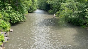
On Sunday, July 16, WVDEP Stream Partners VISTA Jessica Bryzek was meeting people for a float trip on the Buckhannon River. At Hampton, a site just upstream from the City of Buckhannon, they found the river thick with black sediment and decided to paddle on Stonecoal Reservoir instead.
According to WVDEP, the spill did not cause any impact to aquatic life. I interpret this to mean there was no raft of dead fish going down the river. A resident of Alton, WV, a community almost four miles downstream from Alexander, also reported that no dead fish were floating down in the following two weeks. In addition, he had not seen any deposits of coal fines in the river. WVDEP sampled the water and laboratory results did not indicate any adverse impacts to the water chemistry in the streams.
According to MyBuchannon.com, the slug of coal had little effect on the drinking water. The City of Buckhannon’s Water Department reported that they did not have to stop preparing water, they only needed to add more flocculant and adjust the chemicals they use to maintain the pH in the water. Flocculant helps particles in the water settle to the bottom of a tank. The spill raised the pH of the water slightly.
Following the spill, WVDEP issued three notices of violation (NOVs) to the company. One NOV was for failure to maintain a sediment control structure; another was for causing a Condition Not Allowable (CNA) in the waters of the state.The third was for failing to notify The Spill Line within 24 hours of the spill. CNA is a term that comes from the state’s 47CSR02 rule on water quality standards. That rule states:
No sewage, industrial wastes or other wastes present in any of the waters of the State shall cause therein or materially contribute to any of the following conditions thereof: Distinctly visible floating or settleable solids, suspended solids, scum, foam or oily slicks
The Spill Line is an important component in emergency management. The Spill Line can contact all the water plants downstream to make sure they know that some kind of pollution is coming.
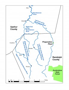
It is easy to get tangled up in the Buckhannon River’s branches.
The mainstem of the Buckhannon River flows north from Alexander 22 miles to the City of Buckhannon and then another 23 miles to the Tygart River near Carrollton, 5-½ miles upstream from Philippi. The Left Fork and the Right Fork of the Buckhannon River meet in Alexander, WV. The preparation plant where the coal spilled is approximately ten miles upstream on the Left Fork, which flows down from the western side of Kumbrabow State Forest. The spill blackened the water for more than 30 miles. The Right Fork has its own Left and Middle Forks: Helvetia is on the Left Fork of the Right Fork. Silica and Pickens are on the Right Fork.The coal seams mined near the Preparation Plant, Sewell, Sewell A, Peerless, and Hughes Ferry, have less than 1% pyritic sulfur, whereas the Lower Kittanning Coal Seam has 1.8% pyritic sulfur. Pyrite is the mineral that oxidizes to form sulfuric acid and dissolved iron in acid mine drainage. The Buckhannon River Watershed Association and West Virginia Water Research Institute have built five projects to combat AMD from the Lower Kittanning in tributaries near Alton and Alexander.
The Carter Roag facility is not actively mining coal; however, the prep plant is currently processing the last of the recently mined coal. Once that is complete, the plant will not be operational and remaining clean coal stockpiles will be shipped out by rail and the company will then begin cleaning up and reclaiming the area.
WVDEP’s Division of Mining and Reclamation will continue to conduct regular inspections through the final reclamation to ensure the facility is complying with the terms and conditions outlined in their permit and state code.

